
CorelentraBooks
Interactive satellite property measurement software for contractors. Trace perimeters, calculate linear footage, create project layout drawings for city permits, and embed on contact forms with zero external API fees.
Stop losing lucrative contracting jobs before the initial site visit. Trace fence paths, roof boundaries, and lot perimeters on high-resolution satellite imagery to generate accurate linear footage estimates, layout drawings for city permits, and instant material breakouts.
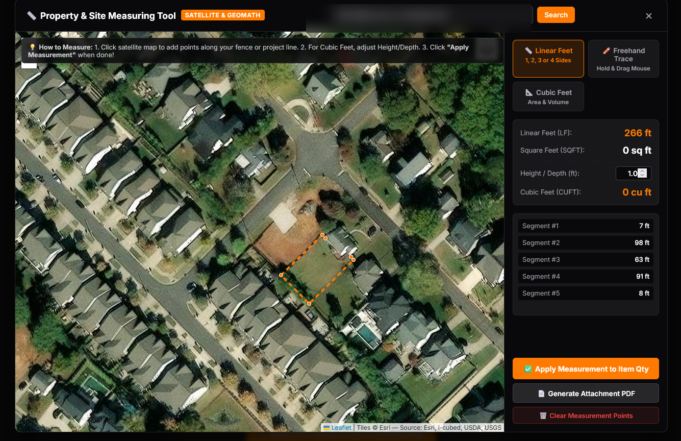
Interactive Satellite Map Measurer running natively within Corelentra CRM & Quoting Workflows
In the fast-paced contracting industry, speed to quote is the #1 factor in winning jobs. Corelentra’s Satellite Property Measurement Tool is uniquely designed to operate in two distinct modes across your sales pipeline:
Company employees, estimators, and project managers can launch the map measurer directly inside any Lead or Quote file. By entering an address, sales reps instantly view sharp ESRI satellite imagery. Estimators click to place vertex points, trace property lines, adjust corner angles, and measure fence segments or roof boundaries in seconds—generating instant linear footage without leaving the office desk.
Empower prospective customers to measure their own properties prior to requesting a quote! By embedding the interactive map widget on your website contact forms (contact.php), homeowners can search their street address, draw their desired fence path or project perimeter, and submit their contact details alongside a crisp, scaled property drawing PDF.
Competing contractor software tools (such as ArcSite, RoofSnap, or Jobber integrations) force contractors to register for complex Google Maps Cloud accounts, enter personal credit cards, and pay hundreds of dollars per month in pay-per-request tile fees.
With Corelentra Books Premium, NO external API keys or third-party subscriptions are required! High-resolution ESRI World Imagery satellite tiles, geocoding engines, Web Mercator projection geometry, and vector PDF rendering are built natively into your subscription. You save $200 to $500+ every month in external API overhead while delivering a world-class mapping experience to your clients.
Standard estimation calculators only output a single number for total linear feet. Corelentra's mapping engine goes three steps further:
| Feature Capability | Corelentra Books | Traditional CRM's |
|---|---|---|
| All-in-One CRM & Invoicing | Included (Built-in) | Included |
| Customer Portals | Included (Basic Tier) | Requires Paid Sync Tool |
| Android IOS Apple Apps | Included (Basic Tier) | Sometimes Provided |
| Card Payment Portal | Included (requires Square or Stripe Connection) (Basic Tier) |
Requires Add-ons |
| Secure Subcontractor & Vendor Portals | Included (With E-Signing) | Requires 3rd Party App |
| Secure Customer & Vendor Portals | Included (With E-Signing & Payments) | Requires 3rd Party App |
| Dynamic Materials Calculator | Included (With Custom Formulas) (Advanced Tier) | Not Available |
| Timesheets & Payroll Logs | High Monthly Fee Per Employee | |
| Scheduling & Calendar Sync | Included (Advanced Tier) | Requires Paid Sync Tool or Add-Ons |
| E-Commerce WooCommerce Sync | Included (Premium Tier) | Requires Paid Sync Tool |
| Map Measuring Tool Admin & Contact Forms | Included (Premium Tier) | Requires Paid Sync Tool
Requires Additional outsourced subscription |
Integrating satellite map measurements directly with your CRM and double-entry bookkeeping eliminates costly estimation mistakes before work begins. Precise perimeter measurements ensure that quotes reflect exact material and labor costs, locking in healthy gross profit margins on every project. Auto-attached PDF drawings reduce pre-construction site visits by over 60%, allowing your sales team to handle double the quote volume per week. Eliminating third-party satellite tile fees keeps administrative overhead low, driving maximum return on investment and empowering your business to expand into high-volume residential and commercial markets.